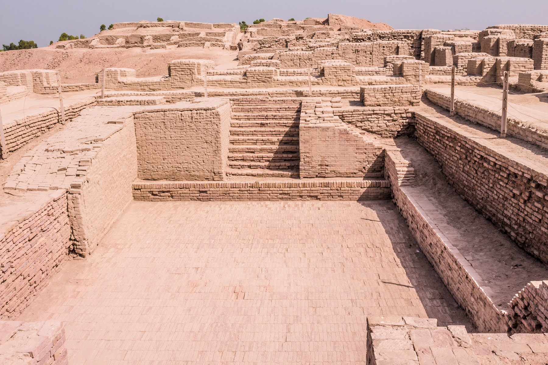
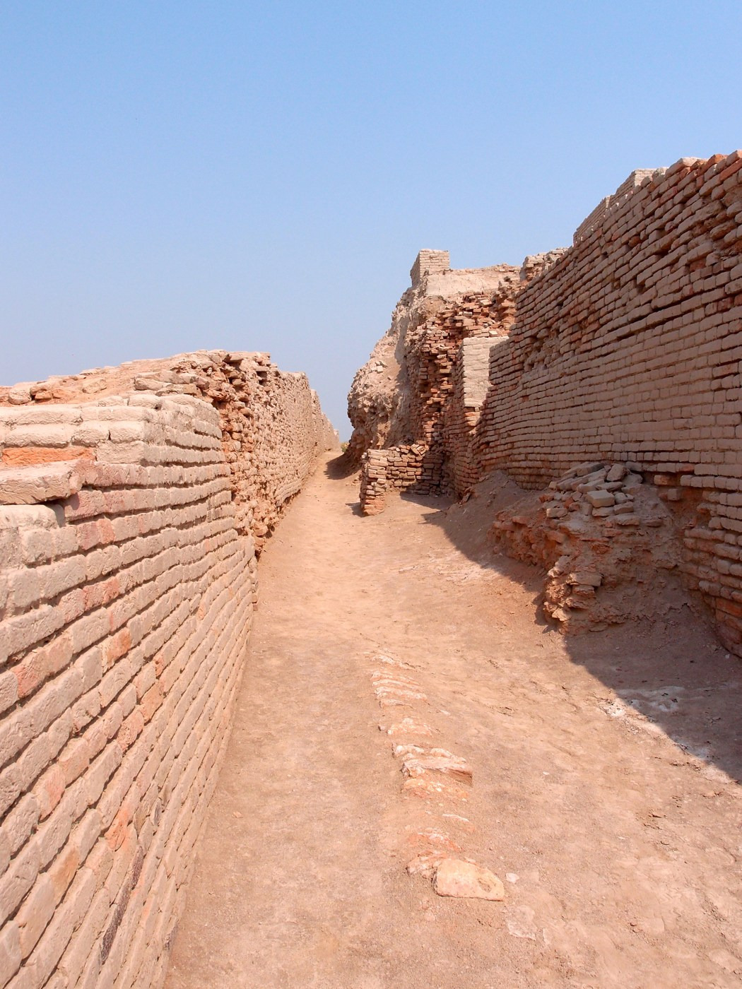
A well stands above the excavated rooms like a short brick chimney. Nearby, a narrow lane runs between walls. Elsewhere, steps descend into a broad, empty tank. At Mohenjo-daro, water is absent from many of the structures built to handle it. Their shapes still let us follow part of its journey through the city.
Begin with a practical question: how could households get water, use it and send it away while living close together? Wells, paved washing surfaces and drains offer connected answers. They also make an ordinary boundary visible. Water could be drawn inside a building; once used water entered a street drain, its passage depended on more than that household alone.
PLACE & TIME
Mohenjo-daro in the Indus plain
Mohenjo-daro
Indus plain · Sindh, Pakistan
c. 2600–1900 BCE
Period explored
Find your bearings before following a drain
Mohenjo-daro was one of the major cities of the Indus civilization. Its best-known urban remains belong to the third millennium BCE, within the Mature Harappan period conventionally placed around 2600–1900 BCE. Jonathan Mark Kenoyer’s site overview describes fired-brick buildings alongside structures using mud brick and timber. The surviving brickwork is a substantial part of a city whose other materials have been preserved less completely.
For orientation, the western high mound is commonly called the “citadel”; the extensive excavated areas farther east are called the “Lower Town”. These are useful archaeological labels. They should not turn the site into a simple diagram with rulers on one side and everyone else on the other. Kenoyer notes domestic and craft activity across the major mounds, as well as large houses in different sectors.
A street joins buildings—and separates them
A lane is both a route and the space between properties. Its alignment tells us how neighbouring structures fitted together. A drain along that route adds a further relationship: a place where water from a building could pass into a channel beyond its walls. To understand that connection, follow an outlet as well as the street’s direction.
UNESCO’s site account describes streets intersecting at right angles. Such regularity supports organised urban layout, but a neat line on a plan cannot name the person who authorised it. Nor does the plan freeze the city at one date. The important next question is which walls, floors and channels belonged to the same phase.
READING THE RUINS
Three distinctions that make the city clearer
Baked brick
Clay brick hardened by firing. Mohenjo-daro also used mud brick and timber; surviving baked brick is especially conspicuous in wells, drains and walls.
Bathing platform
A paved surface from which used water could drain. Its presence supports washing or bathing; it does not automatically identify a toilet or a room with running taps.
Occupation level
A surface or deposit belonging to a phase of use. Rebuilding can put newer floors above older ones; walls visible together today need not have stood together at one moment.
The well brings the water source close to home
Drawing water requires a source and a way to reach it. A well moves that access into a particular courtyard, building or neighbourhood. At Mohenjo-daro, wells were distributed among built-up areas. Kenoyer’s description of a private well in DK-G places one or more wells within building blocks: water access was woven into the city’s architecture.
The distinction between a private and a public well is about approach as much as construction. A well documented in the HR area could be reached directly from the main street, whereas many others lay within private buildings. An entrance, passage and surrounding walls can therefore tell us something important about access, even when the names of the users are unknown.
Bricks shaped for a circle
A well also demanded a particular kind of brickwork. In his description of a large well in the HR area, Kenoyer records wedge-shaped bricks used to form a strong circular structure. Some bricks had grooves that kept a drawing rope from sliding sideways. The builders were adapting clay shapes to the task of repeatedly raising water, not merely extending an ordinary straight wall.
Access is a clue to daily effort
Consider the difference between entering a building to reach a well and approaching one from a street. Those routes offer different possibilities for sharing. They do not reveal a water tariff or an owner’s legal rights, but they make an everyday constraint concrete: somebody had to reach the source, raise the water and bring it to where it was needed.
A nearby well could shorten that work. It did not supply modern plumbing. The distance from source to washing surface, the size of a doorway and the available space around the well matter when reconstructing how water was handled. Architecture can recover parts of a task without recovering the household’s timetable.
- Find the approach: a street entrance, courtyard or interior passage changes how a well could be reached.
- Trace the route from source to use: drawing water was only part of the work.
- Compare levels: the exposed ground today may lie below the surface beside the well when it was used.
LOOK CLOSELY
Read the well, not just its height
Follow the circle
The well has its own circular brick structure among the surrounding walls.
Look at the ground
Excavation removes deposits around a well. Its exposed height is not automatically its original height above a floor.
Keep the date separate
A modern photograph records the exposed ruins; it does not date every visible brick course.

Exposed brick well at Mohenjo-daro · photographed in 2010.
The photograph illustrates an exposed well; it does not identify the particular well in Kenoyer’s DK-G caption. That caption describes the removal of surrounding fill while the well was left standing to indicate its final level of use. Excavation can therefore explain an apparent tower without making one part of the ancient street.
A paved floor gives used water a route out
A water source solves only the first part of the problem. Washing leaves water on a surface, and a confined room needs somewhere for it to go. A well and bathing platform documented in DK-G bring source and use together: a stair led from a lower room to the well and a carefully constructed platform.
A paved surface associated with drainage gives a practical basis for a bathing or washing interpretation. It provides a place to use water and a route for removing it. The physical arrangement is more informative than describing every such room as an ancient “bathroom”, a word that can smuggle in fittings and uses that the excavation has not established.
FOLLOW THE PROCESS
From a well to a street drain
Draw water
A well brings the water source into a building or neighbourhood.
Carry it
Water still has to reach the place where it will be used.
Use it
A paved washing surface provides a place for water to drain.
Let it flow away
An outlet can connect that surface to a channel beyond the house.
Water disposal does not mean a modern sewer
A civil-engineering study by Takashi Nakamura and colleagues approached the remains through water-supply capacity, rainfall and the arrangement of wells, channels and soak pits. Its published English abstract concludes that the drainage system appears to have served mainly to remove wastewater from paved rooms near wells. That is a useful, specific explanation of what much of the network was doing.
The connection to examine is a water-use surface, an outlet and a disposal route. A drain can carry water away without establishing flush toilets, a continuous piped supply or a modern treatment system in every household.
At the street, a household task becomes shared work
The channels described in Harappa.com’s account of Mohenjo-daro’s drains were built of closely fitted baked brick. Many street drains had removable brick covers; wider spans could use limestone slabs. Settling places and traps allowed material to collect before it passed farther through the system. These details concern operation, not simply appearance.
A drain only continues to work if its route stays open. Covers protect a channel while allowing access; a trap concentrates material where it can be removed. These are practical ways of making maintenance possible. The archaeological descriptions of covers and settling places therefore support a city in which water disposal required repeated attention.
KEY IDEA
A drain connects a household task to shared space.
CHANGE YOUR VIEW
One drain, three perspectives
The outlet matters because water has to leave the room where it was used. Follow the practical route beyond the household.
Covers, trapped residue and access for clearing turn construction into an ongoing task.
Walls, floors and drains visible today may belong to different building phases. Their relationships need to be established, not assumed.
These questions follow the operation and interpretation of a shared channel. They do not identify the people assigned to it. A household tending its outlet, neighbours coordinating repairs and a wider authority organising work remain different possibilities.
KEEP THE DISTINCTION
Read each part by its task
Well and its approach
Give people access to a water source.
Was the approach from a street, a courtyard or an interior room?
Paved platform and outlet
Provide a place to use water and remove it.
Does the outlet connect with a recorded drain or disposal feature?
Settling place or trap
Catch material before it travels farther.
Could accumulated material be reached and removed?
Covered street channel
Carry water beyond an individual building.
Which outlets and channel sections belonged to the same construction phase?
The Great Bath gives water a different scale
Domestic platforms bring us close to a household task. The Great Bath, on the western mound, shows a much larger investment in holding water. Kenoyer gives its tank approximate dimensions of 12 metres north–south by 7 metres across, with a maximum depth of 2.4 metres. It occupied a substantial building rather than an isolated hole in the ground.
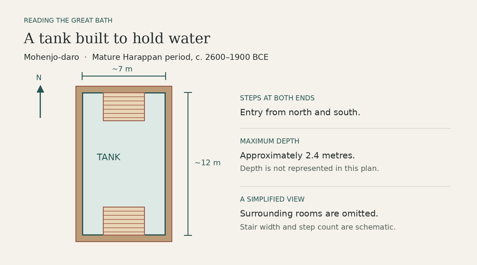
Steps descend at the north and south ends. The archaeological description records tightly fitted bricks, gypsum plaster and bitumen used in making the tank watertight. A well in a room to the east may have supplied water; no inlet drain has been identified in the description. The tank’s existence is clear, while the exact way it was filled remains less certain.
IN THE SOURCE
People coming down the stairs could move along this ledge without actually stepping into the pool itself.
Watertight masonry answers an engineering question: how to keep the tank from leaking. To identify a ceremony, researchers must also interpret the building’s setting and access. Those are related questions, but they require different kinds of evidence. The Great Bath lets us see specialised construction more directly than the institution behind it.
SOURCE CHECK
Does the Great Bath prove a priesthood ruled the city?
The Great Bath identifies a government of priests at Mohenjo-daro.

- What survives
- A substantial brick tank with steps and surrounding building remains, exposed by excavation.
- What the structure supports
- Holding water and entering it were important enough to justify specialised construction. A ceremonial use is plausible.
- What needs another source
- Identifying priests, rules of admission or governing authority would require independent evidence. The Indus signs do not supply an accepted readable account of these offices.
Verdict
The tank supports an important collective use of water. Ritual purification is a common interpretation. Its construction does not identify a priestly office or establish who governed the city.
Read the archaeological description Jonathan Mark Kenoyer: the Great Bath · Wellcome Collection · CC BY 4.0 · resaved; displayed crop
An old building name can become an unearned fact
The neighbouring structure often called the “granary” offers a second warning. Kenoyer stresses that its function has not been established. A substantial foundation and provision for a wooden superstructure support a major building. They do not, by themselves, establish grain storage. The familiar name records an interpretation, not a securely identified use.
These distinctions improve the picture of urban organisation. Large buildings, specialised water facilities and substantial houses make differences in scale visible. They give us things to investigate: access, construction, storage, gatherings and the relationship between rooms. Replacing every uncertain function with a confident label would erase the very questions the architecture can help answer.
Could this have been a city without rulers?
The previous chapter followed named rulers in Sumer through inscribed monuments and seals. Mohenjo-daro changes the evidence available to us. Indus signs survive on objects, but they do not provide an accepted reading of an administrative order, a ruler’s title or a set of responsibilities for maintaining these drains.
In their study of inscribed objects from Harappa, Jonathan Mark Kenoyer and Richard Meadow distinguish undeciphered signs from the archaeological contexts in which objects were used. Their introduction and methodological note explain why those contexts can still illuminate social and economic activity. Harappa is a different city; its evidence helps explain the method rather than supplying a government for Mohenjo-daro.
An equally tempting shortcut is to turn disputed palace identifications into proof that nobody ruled. Massimo Vidale’s study of possible palace-like complexes at Mohenjo-daro argues for elite residences and questions what archaeologists mean by “palace”. His interpretation does not settle the political system, but it demonstrates why “no obvious palace” is an insecure foundation for a claim of equality.
We can make a firmer claim at a different level. The city’s water arrangements crossed the boundaries of individual activities: sources, places of use and disposal routes had to fit into built-up space. That is evidence of organised urban life. Whether its coordination relied on particular elites, institutions or neighbourhood arrangements remains a question for further evidence.
Read a city that kept changing
The ruins are not one intact city emptied on a single day. Kenoyer’s chronology notes that the familiar excavations concentrated on upper occupation levels, with earlier deposits below. Crafts were practised in different sectors, including copper work, shell carving and the production of beads and ceramics. Water infrastructure belonged to that busy urban setting and to successive changes within it.
For a drain or well, continuity can mean repair rather than untouched survival. Harappa.com’s drainage account describes channels raised with additional brickwork over time. The next step in reading a channel is therefore to compare its height and construction with adjoining floors. A feature reused in a later phase can preserve a connection while altering its level.
LAYERS OF TIME
One site, several kinds of change
- Urban occupation
Building and use
Wells, washing surfaces and channels made room for repeated everyday needs.
- Successive phases
Rebuilding
New floors and structures could alter relationships between older features.
- Excavation
Exposing the remains
Removing surrounding deposits changed what stood above the visible ground.
- Conservation
Protecting the ruins
Repairs and protective layers are part of the present-day appearance.
Phase labels describe different processes; they are not precise dates for every visible structure.
Today’s conservation introduces another layer. UNESCO records salt damage, rain and thermal stress among the site’s problems, with mud slurry, protective capping and consolidation among the responses. Kenoyer’s well-and-platform caption specifically identifies protective mud-brick covering and clay slurry. A modern photograph can show an ancient structure under a modern protective surface.
Even the Great Bath’s colonnade needs that distinction. Kenoyer notes that columns found along three sides informed reconstruction on the missing western side. The tank, the excavators’ exposed remains and later conservation belong to the history of the place. Reading them separately makes the ancient evidence more useful.
What the waterworks finally reveal
The wells and drains reveal a city making room for repeated needs: access to a source, a place to use water and a route for removing it. Some of those routes crossed the boundary of a household. Their construction and upkeep belonged to urban life as much as the large buildings that dominate a site plan.
The wells and drains give us a close view of that urban achievement. They show how buildings could make room for repeated needs in a densely occupied place. The next time an ancient city is described as “well planned”, ask what the plan made possible. Here, part of the answer lies in a route from a well to a washing surface—and in the work needed to keep used water moving away.