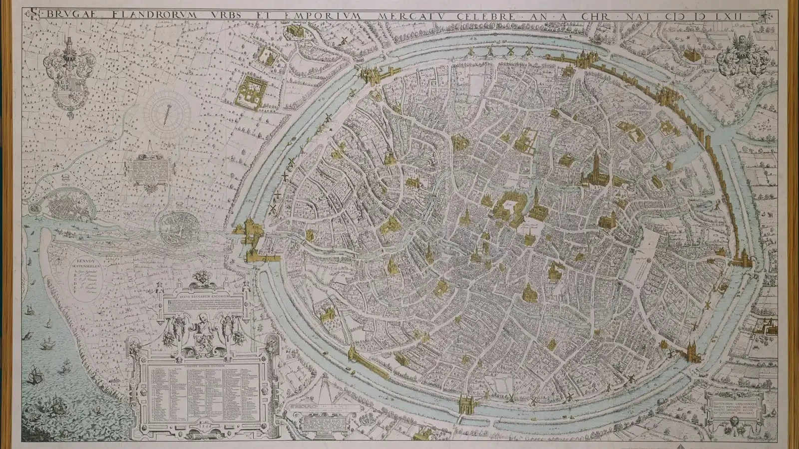
Bruges commissioned an ambitious map in 1562, long after its medieval commercial peak. Marcus Gheeraerts represented buildings, streets and the city’s connection towards the sea in remarkable detail. This was not the action of a place that had simply ceased to matter. It was a city making its usefulness visible while trying to improve its prospects.
The map offers a good place to begin the question of decline. Bruges lost its leading position in international trade, but commercial leadership, the survival of a population and the use of urban buildings are different things. The familiar story in which a harbour silts up and a whole city immediately stops working collapses those differences into one event.
PLACE & TIME
From a leading market to a changing city
Bruges and its connected settings
Historical County of Flanders · present-day Belgium
1400–1562 CE
Period and setting
A changing waterway created a problem people could respond to
Bruges depended on its harbour landscape, but that landscape was never a permanently fixed route. Sediment and changing channels affected access. Research on the Zwin combines environmental history with archaeological and written evidence. These processes mattered because ships, landing places and the movement of goods had to remain connected.
Physical change does not make human response irrelevant. People could shift activities between ports, alter facilities or invest in improved connections. Such responses took resources and could benefit some places more than others. A geographical disadvantage became an economic problem through the cost and effectiveness of the available alternatives.
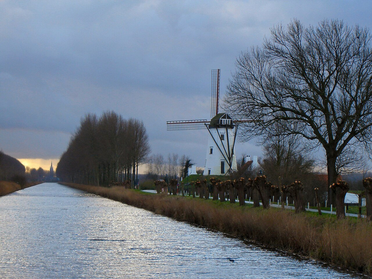
Monnikerede illustrates the interaction particularly clearly. The archaeological project links its decline with economic and political developments as well as silting. It also identifies the consequences of a later canal connection that bypassed its harbour. A work intended to support the wider system could leave a particular settlement less useful within it.
FOLLOW THE CONNECTIONS
Ask what changed, then who could adapt
Access
Which routes and facilities remained practical for the movement of ships and goods?
Alternatives
Where else could merchants obtain buyers, credit and commercial connections?
Capacity to respond
Who could finance a new link, negotiate useful terms or move a business elsewhere?
These questions keep the physical explanation in its proper place. Water access was necessary for maritime commerce, but access alone could not guarantee that merchants would choose Bruges. The city also had to remain attractive within a changing field of competing markets.
Antwerp’s rise began before the most dramatic Bruges crisis
The sequence matters. If Antwerp was gaining business before the unrest of the late 1480s, that unrest cannot be the beginning of the whole shift. James L. Bolton and Francesco Guidi Bruscoli use evidence from a Borromei ledger for 1438 to argue for an earlier commercial importance of Antwerp than some older accounts allowed.
Their study identifies business involving southern German merchants and fustian, a textile associated with that commerce. The point is not that one ledger measures every form of trade in both cities. It provides evidence that significant alternatives were already operating while Bruges remained important.
COMPARE
Three observations, three different claims
Business recorded elsewhere
Merchants could find a useful market beyond Bruges.
Every merchant had left Bruges at the same time.
Difficult water access
Some routes required adaptation or became less practical.
Environmental change was the only cause of a commercial shift.
Continued urban activity
Bruges retained inhabitants, buildings and businesses.
Every group preserved its former income or security.
Markets attract participants partly because other useful participants are already there. A merchant considering a move could look for customers and services, not merely a deeper channel. This is an explanation of the decision’s possible structure, rather than a reconstruction of the motives of every named trader.
Marcus Gheeraerts, 1562 · Public domain · resized jpeg reproduction.
Political conflict could make an existing alternative more attractive
The previous chapter followed the confrontation with Maximilian. The broader succession struggle involved years of conflict and negotiation. For a commercial centre, political instability could affect confidence, costs and the security of arrangements. These concerns did not need to begin as a dispute about shipping in order to influence trade.
A merchant community had choices that a small working household might not possess. Moving a business was difficult, but some merchants could redirect activity towards another centre. A household tied to local tools, suppliers or customers could be much less able to follow. The consequences of a commercial shift were therefore uneven from the beginning.
KEY IDEA
The timing of alternatives matters when explaining a city’s loss of leadership.
This also explains why a precise date for “the end of Bruges” is misleading. Different businesses could reassess their position at different times. A decline in international importance need not produce an immediate collapse of every occupation, and an individual departure need not mark the departure of a whole community.
Policy and commercial connections mattered too
Research on Bruges’ cartographic and economic history considers trading policies, changing relationships with merchant groups and competition alongside access to water. Its account includes restrictions affecting English cloth and the growth of Antwerp’s opportunities. The problem was broader than a blocked physical route.
A city’s leaders could face difficult choices among interests that did not coincide. Supporting local production and attracting foreign business were related aims, but a measure helpful to one might trouble another. That is a reason to investigate a policy’s effects, rather than assume that every choice was aimed at maximising an undifferentiated quantity called trade.
WORDS TO KEEP APART
Three distinctions that improve the explanation
Commercial leadership
A centre’s leading role in particular trading and financial connections; not a measure of every resident’s welfare.
Adaptation
A response to changed conditions, which can succeed for some participants and impose costs on others.
Urban continuity
The continued use and development of a city, even when its economic role changes.
The continuing need for negotiation is one thread connecting this chapter with the Hanse’s archive. A grant or agreement could secure a particular advantage. It could not freeze the city’s position relative to every other market for all future time.
Marcus Gheeraerts, 1562 · Public domain · resized jpeg reproduction.
The 1562 map made a case for navigability
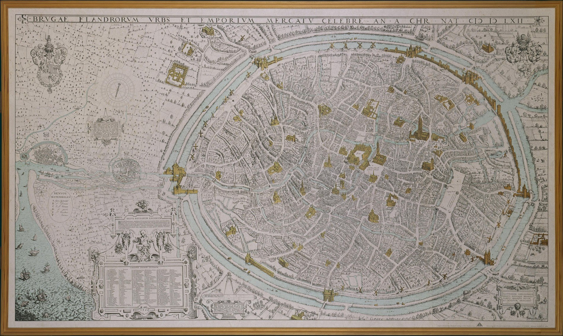
Gheeraerts’ map represented a city still concerned with its connection to the sea. The research on its commission shows that officials wanted navigability to be noticeable. Its waterways were drawn as part of that argument, with differences of scale and presentation that could make the connection look more effective.
That does not make the map worthless or every represented feature fictitious. It makes the document purposeful. The historian can examine the city’s topography and the claim its commissioners wanted to advance. A map designed to attract interest is evidence about an intended future as well as a represented place.
LOOK CLOSELY
A city presenting its prospects
A dense urban image
The map gives buildings and streets a prominent visual presence. It does not depict an empty settlement.
Connections beyond the walls
Water routes link the represented city with a wider landscape. Their presentation should be compared with the map’s commercial purpose.
The date changes the question
The work dates from 1562. It is evidence for that later moment and its representation of the city, not a direct map of Bruges in 1300.

Marcus Gheeraerts’ map of Bruges, 1562. The later map is evidence of a represented urban landscape and a commercial claim, not a direct map of Bruges in 1300.
The image is especially useful after a story of decline because it records continued agency. Municipal officials still pursued ways of improving access and reputation. An effort might be costly or inadequate without being meaningless. Explaining why leadership shifted should not remove the people who tried to influence what happened next.
A city could remain inhabited and still become less secure for some
A later study of roughly 150 houses in three Bruges neighbourhoods challenges the idea that the city simply shrank away after its golden age. Vrije Universiteit Brussel’s account of Heidi Deneweth’s research describes continued adaptation and regional activity. The study follows a longer post-medieval period and selected areas, rather than providing a census of every late medieval household.
Continued use of houses does not mean continuity of everyone’s fortunes. Property owners and people with little reserve could experience economic change very differently. The survival of a building can be easier to establish than the security of each household that occupied it. Those questions require different records.
- Do not equate loss of leadership with an empty city.
- Do not equate a surviving building with unchanged livelihoods.
- Do not give every merchant group or occupation the same timetable.
Decline was a change in relationships
Bruges’ leading position depended on the interaction of a harbour landscape, specialised services, production and negotiated rights. Its weakening involved changes in those relationships and the attractiveness of alternatives. Silting belongs in the explanation, alongside commercial competition, policies, conflict and uneven possibilities for adaptation.
The city’s later efforts show why the story should not end with a deserted medieval skyline. Bruges continued to act, build and work in different circumstances. The final chapter returns to the path’s central question: what does this changing city reveal about the ways wealth and power were connected, and about the people who shared in their benefits?